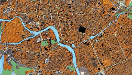
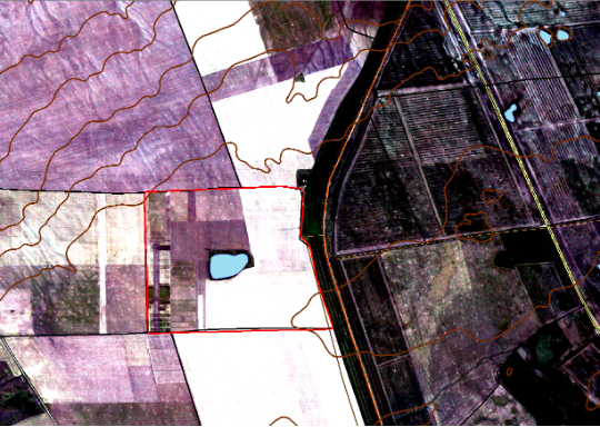
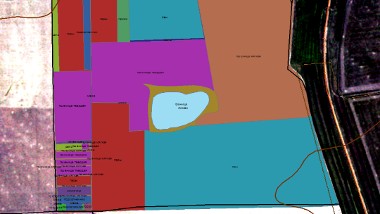
Cartography
Description of high value-added geoproducts in the field of cartography
            REGIONAL SPATIAL DATA (RSD)
a set of medium- and large-scale (1:100,000 - 1:10,000) spatial data (raster, vector and attributive) for the area, obtained on the basis of L3, L4, L5 products with extension options.
2. Raster data
Raster data includes basic products L3 - L5, created on the basis of space images from KazEOSat-1 and KazEOSat-2 satellites. The data can be provided as a set of orthorectified space images (L3), covering the area, or as a single orthorectified mosaic (L5) for the entire area. Product L4 - will be used as a source of relief information.
 
			 
			2. Vector data is provided as a GIS or geodatabase and includes a basic set of vector layers:
• boundaries of the region;
• boundaries of the region's districts;• boundaries of settlements;
• road network;
• relief;
• hydrography.
- Expansion option - possibility to include additional vector layers and create a GIS based on remote sensing data to solve industry thematic tasks in the field: - agriculture;
•  the use of forest resources;
• the use of water resources;
•  geology and subsoil use;
•  prevention and elimination of the consequences of emergencies; 
and etc. 
 3. Attribute data
Descriptions, lists, registers and classifiers to geographical objects.
 
			 
			SPATIAL DATA OF SETTLEMENTS (PD NP)
a set of large-scale (1:10,000 – 1:5,000) spatial data (raster, vector, and attribute) for settlements derived from L3, L4, L5 products with extension options.
1. Raster data
Raster data includes basic products L3 - L5, created on the basis of space images from the KazEOSat-1 spacecraft. The data can be provided as a set of orthorectified satellite images (L3) covering the territory of the NP, or as a single orthorectified mosaic (L5) for the entire territory of the NP. The L4 product will be used as a source of information about the terrain or the height of objects on the ground.
2. Vector data
Vector data is provided in the form of a GIS or geodatabase and includes a basic set of vector layers:
- NP boundaries;
- borders of NP districts;
- road network;
- residential and industrial quarters;
- hydrography;
- relief.
 
			 
			Опция расширения – возможность включения дополнительных векторных слоев и создания ГИС для решения тематических задач:
- геодезические пункты; 
- инженерные сети; 
- промышленные объекты; 
- транспортная инфраструктура; 
- объекты недропользования; 
- гидротехнические сооружения; 
- растительность; 
и т.д.
 3. Attribute data
Descriptions, lists, registers and classifiers to geographical objects.
LOCAL SPATIAL DATA (LSD)
a set of medium- and large-scale (1:100,000 - 1:5,000) spatial data (raster, vector and attributive) for individual territories obtained on the basis of L3, L4, L5 products with extension options.
1. Raster data
Raster data includes basic products L3 - L5, created on the basis of space images from KazEOSat-1 and KazEOSat-2 spacecraft. The data can be provided as a set of orthorectified satellite images (L3) covering the area of interest or as a single orthomosaic (L5) for the entire area of interest. Product L4 - will be used as a source of information about the terrain or the height of objects on the ground.
2. Vector data
Vector data is provided in the form of a GIS or geodatabase and includes a basic set of vector layers:
- relief;
- boundaries of the zone of interest;
- road network;
- hydrography.
 
			 
			Extension option - the ability to include additional vector layers and create a GIS for solving individual thematic tasks:
- Agriculture;
- use of forest resources;
- use of water resources;
- geology and subsoil use;
- prevention and liquidation of consequences of emergency situations
etc.
 3. Attribute data
Descriptions, lists, registers and classifiers to geographical objects.
ORDER A SERVICE!
 
	ордбораопаопбаопопбсабопборбмбр
OUR SERVICES
CONTACTS
- 
						Astana, Nura district, Turan avenue 89 
 National Space Center
- 
						+7 (7172) 76 94 15 Reception 
- 
						+7 (7172) 76 94 11 office 
- 
						+7 (7172) 24 85 50 вн.307 Compliance - Officer 
- 
						kense@gharysh.kz Reception 
